Building Habitat Connectivity for Climate Adaptation
A California Landscape Conservation Partnership place-based adaptation project
Mayacamas to Berryessa (M2B) Coast Ranges, California
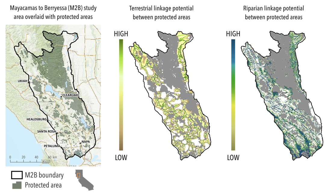
Climate change is impelling a universal redistribution of species, with pervasive and substantial impacts on ecosystem functioning and human well-being. The most frequently promoted strategy for biodiversity conservation is increasing habitat connectivity, which has predominantly relied upon fixed networks of protected areas. However, these static networks have a limited ability to accommodate species range shifts due to the combined impacts of land use and climate change. Evaluations of connectivity between protected areas have failed to consider how reductions of suitable habitat – as a result of land conversion, habitat loss, or fragmentation – will interact with climate change. Proactive protected area network planning and management depend upon explicit inclusion of these ecosystem responses in decision-making and strategic frameworks. Insight about linkages that facilitate resilience to climate change should be incorporated into conservation assessments to ensure adequate habitat connectivity, mitigate exposure to extreme microclimates, and provide more time for species to shift.
Within this theoretical framework, this research proposes to integrate connectivity and linkage analyses with high resolution climate models to identify locations across that offer both habitat and climate connectivity. Building on existing relationships with stakeholders, we develop and conduct these analyses to evaluate landscape connectivity for climate adaptation between the Mayacamas and Berryessa ranges in Northern California in collaboration with conservation practitioners to ensure the data products are informed by and meet existing conservation needs. Specifically, we generated maps of linkages between protected areas and evaluate the climate connectivity of the linkage network to identify locations that offer the greatest climate change benefits. For these analyses we used high-resolution mapping to model multiple stressors to connectivity, as well as future climate emission scenarios to evaluate the adaptive potential of the existing protected area network.
Learn more about this project on the Climate Commons.
Mayacamas to Berryessa (M2B) Coast Ranges, California
Climate change is impelling a universal redistribution of species, with pervasive and substantial impacts on ecosystem functioning and human well-being. The most frequently promoted strategy for biodiversity conservation is increasing habitat connectivity, which has predominantly relied upon fixed networks of protected areas. However, these static networks have a limited ability to accommodate species range shifts due to the combined impacts of land use and climate change. Evaluations of connectivity between protected areas have failed to consider how reductions of suitable habitat – as a result of land conversion, habitat loss, or fragmentation – will interact with climate change. Proactive protected area network planning and management depend upon explicit inclusion of these ecosystem responses in decision-making and strategic frameworks. Insight about linkages that facilitate resilience to climate change should be incorporated into conservation assessments to ensure adequate habitat connectivity, mitigate exposure to extreme microclimates, and provide more time for species to shift.
Within this theoretical framework, this research proposes to integrate connectivity and linkage analyses with high resolution climate models to identify locations across that offer both habitat and climate connectivity. Building on existing relationships with stakeholders, we develop and conduct these analyses to evaluate landscape connectivity for climate adaptation between the Mayacamas and Berryessa ranges in Northern California in collaboration with conservation practitioners to ensure the data products are informed by and meet existing conservation needs. Specifically, we generated maps of linkages between protected areas and evaluate the climate connectivity of the linkage network to identify locations that offer the greatest climate change benefits. For these analyses we used high-resolution mapping to model multiple stressors to connectivity, as well as future climate emission scenarios to evaluate the adaptive potential of the existing protected area network.
Learn more about this project on the Climate Commons.
The importance of land use for accurate species distribution models
|
Species distribution models are relied upon for wise land use planning in the urban-wildlife interface where conservation and development efforts can conflict. Although the built environment influences species’ distributions, these models rarely include land use. Further, existing species distribution models can over predict suitable habitat for individual species, communities, or potential refugia in the face of climate change.
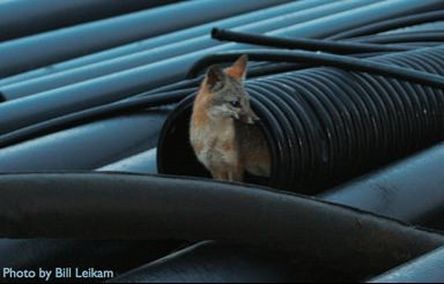
Here we examine the relative influence of human land use for species distribution modeling of gray fox (Urocyon cinereoargenteus) including a comparison of the results using presence-only data from citizen scientists with presence/absence data from research transects across an urban-wildland gradient. We used a combination of nine environmental and land use variables, and two sources of gray fox location data, to create maximum entropy (MaxEnt) models: 100 presence-only observations collected by citizen scientists and 209 presence/absence observations collected by academic researchers. All observations were collected in California between 2006 and 2016. To account for sampling bias, detections of non-gray fox species in the order Carnivora were used as background pseudo-absence points. We analyzed all variables in terms of their effect on model accuracy, variable importance score, and overall spatial prediction. Regardless of location data source, including human land use variables improved the accuracy of the MaxEnt model. Models with land use predicted clusters of concentrated gray fox occurrence across a larger portion of the study area; models with only bioclimatic variables predicted dispersed distributions. Further, models generated using citizen-science collected data predicted more land was suitable for gray foxes overall. Our results indicate that including human land use improves the resolution of model predictions in and around the built environment for the gray fox. Additionally, using citizen science data can be informative in distribution models, improving spatial coverage and providing better insight into the important drivers of species distributions. |
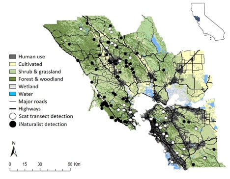
A map of the study area depicting six counties in the San Francisco Bay Area showing scat transect (white) and iNaturalist (black) gray fox detections. General groups of vegetation and land use types, as well as major roads and highways, are indicated.
|
Evaluating connectivity map predictions
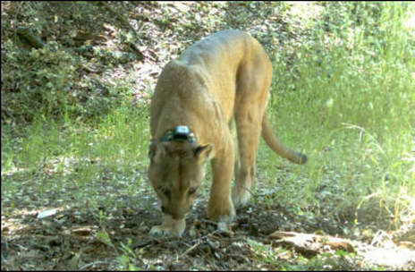
Radio-collared puma in the Santa Cruz Mountains, CA. Image credit: Bay Area Puma Project, 2010
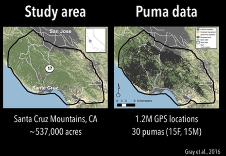
(L) A map of the study area in the Santa Cruz Mountains, situated between San Jose and Santa Cruz, CA. (R) The study area overlaid with the puma points we sampled from 2008 to 2013.
|
Habitat fragmentation in human-dominated landscapes is seen as a major threat to biodiversity persistence. Nearly all corridor conservation plans designed to restore habitat connectivity are based on modeled data, and are rarely tested with empirical field data. For this project, I compared a simple, biologically informed model that predicts landscape permeability for wildlife movement using occurrence data from a large-bodied predator across a gradient of land use in the Santa Cruz Mountains, CA.
In collaboration with Dr. Adina Merenlender and Dr. Chris Wilmers, I compared three general landscape feature-based permeability models with species occurrence data for pumas (Puma concolor) in California’s Santa Cruz Mountains. Each model was derived from a estimated linear relationship between a specific landscape feature related to the built environment (distance to roads, mean parcel size, and median patch size) and observed responses by bird and meso-carnivore assemblages from the literature. Our results showed that observed puma movement in the Santa Cruz Mountains corresponded with the modeled permeability gradients. Specifically, pumas were observed to readily use moderately disturbed habitats, and rarely were detected in the most heavily disturbed areas. This comparison of a more generic connectivity model estimate with animal field observations shows that while generic models can be useful for corridor designs in highly disturbed environments they may be less useful in moderately impacted rural to semi-natural landscapes, where more detailed studies of species behavior may be required to delineate functional corridors. Mapping the level of landscape permeability that surrounds the built environment, as measured by distance to roads and housing density, offers a spatially explicit way to identify areas important wildlife movement. This approach provides a tool to help managers and land-use planners quickly and affordably prioritize habitat corridors for biodiversity conservation across fragmented landscapes, even when species data are unavailable. A PDF of the full article in Landscape and Urban Planning is available here. |
